Geographic Information Systems (GIS) have become essential tools in various industries, from urban planning to environmental conservation. But, as the complexity and scale of geographic data grow, so does the need for more sophisticated ways to manage that data. Enter the database—an integral component of modern GIS systems. Without databases, handling, analyzing, and storing large sets of spatial and attribute data would be inefficient and prone to errors.

Understanding GIS (Geographic Information System)
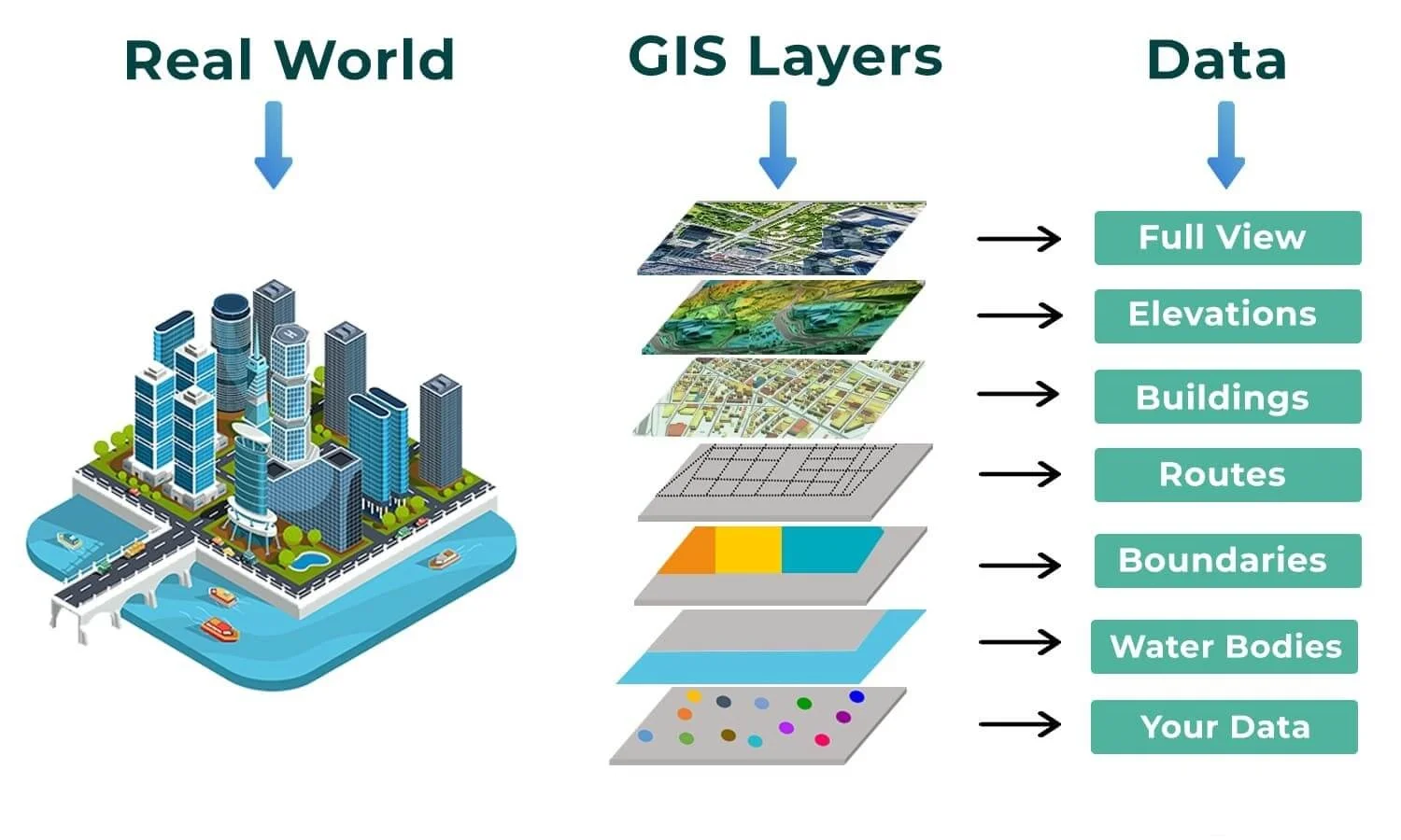
At its core, a Geographic Information System (GIS) is a system designed to capture, store, manipulate, analyze, and visualize geographic data. It allows users to understand spatial patterns, relationships, and trends by linking data to its geographical location. Think of it as a combination of digital maps and rich data layers, all working together to give deeper insights into specific locations.
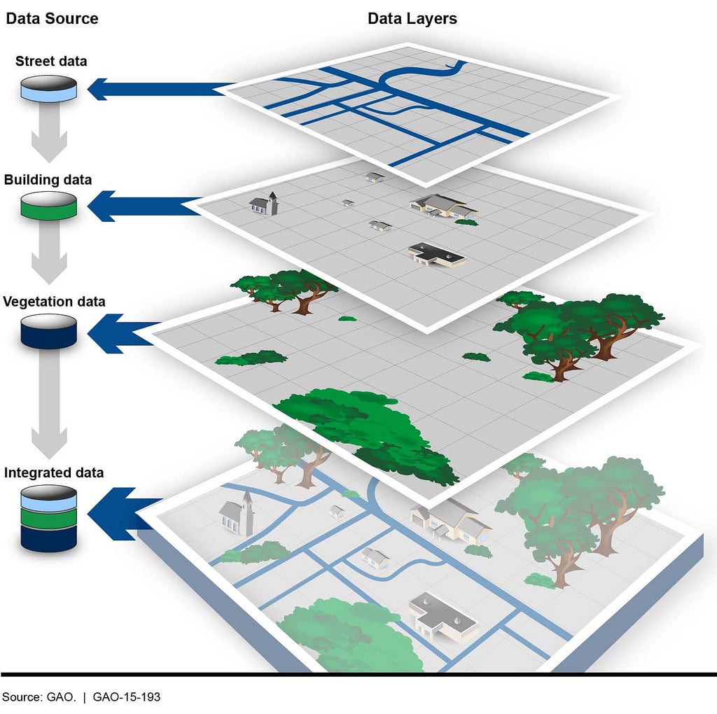
Whether it’s for urban planning, environmental monitoring, or disaster management, GIS serves as a powerful tool for making informed decisions. By overlaying different types of data, such as population density, land use, and infrastructure, GIS enables more efficient planning and resource management.
Key Components of GIS:
- Hardware: Computers and servers where the GIS software runs.
- Software: Specialized programs (like ArcGIS, QGIS) that provide the tools for mapping, spatial analysis, and data management.
- Data: The geographic data sets used within the system, such as satellite images, demographic data, and environmental information.
- People: Analysts and professionals who gather, interpret, and use the data.
- Methods: The methodologies and practices for collecting and analyzing spatial data.
GIS software brings together geographic (spatial) data with attribute data, allowing users to see and analyze information about “what” and “where.”
Core Functions of GIS
The power of GIS lies in its versatility and capability to perform multiple tasks simultaneously. Below are the core functions that make GIS indispensable across many fields:
- Data Collection: Gathering geographic data from sources like satellites, GPS, surveys, and sensors.
- Data Storage: Managing large datasets efficiently. This is where the database becomes crucial, as it allows for secure, scalable storage of both spatial and attribute data.
- Data Analysis: Performing complex spatial analyses, such as identifying patterns, predicting outcomes, and optimizing resources. For example, GIS can help urban planners decide the best location for new infrastructure based on traffic patterns and population density.
- Data Visualization: Displaying data in the form of maps, graphs, and reports. Visualization is one of the most recognized features of GIS, making it easier to interpret large amounts of data at a glance.
Examples of GIS in Action:
- Urban Planning: GIS helps planners analyze land use, zoning, and future growth areas, ensuring well-planned, sustainable development.
- Environmental Monitoring: It plays a pivotal role in tracking deforestation, pollution levels, and biodiversity conservation.
- Disaster Management: GIS assists in disaster preparedness and response, by mapping hazard zones, evacuation routes, and emergency resources.

What is a Database?
Definition of a Database
A database is an organized collection of data that is structured to allow easy access, management, and updating. In essence, databases store data in a way that enables fast retrieval, manipulation, and querying, ensuring that large datasets can be efficiently managed. Databases are critical in today’s digital world, providing the backbone for everything from banking systems to GIS applications.
A database is usually organized in a series of tables that contain rows (records) and columns (fields), where each column represents a specific type of data, and each row represents an individual entry in the dataset. This structured approach allows databases to maintain data integrity, making sure the data is accurate and consistent over time.
Key Characteristics of Databases:
- Data is structured: Typically in tables, making it easy to search and retrieve specific information.
- Scalability: Databases are designed to handle small to massive volumes of data.
- Security: Databases come with built-in security features like encryption, user access control, and data validation.
- Data Consistency: They maintain consistency by ensuring that only valid data is entered or retrieved.
Different Types of Databases
GIS systems can use various types of databases, depending on the scale of the project and the complexity of the data. Understanding the types of databases is essential when determining which is most suitable for a particular GIS application.
- Relational Databases (RDBMS): These are the most common types of databases. They store data in a structured format using rows and columns and rely on Structured Query Language (SQL) for data management. RDBMS systems are widely used in GIS because they support relationships between different types of data, making them ideal for spatial data analysis.Examples: PostgreSQL/PostGIS, MySQL, Microsoft SQL Server.
- NoSQL Databases: Unlike relational databases, NoSQL databases do not rely on tables. They are designed to handle large volumes of unstructured data, making them suitable for real-time applications and big data analytics. NoSQL databases are gaining popularity in GIS for managing unstructured spatial data like geotagged social media posts or sensor data.Examples: MongoDB, Couchbase.
- Spatial Databases: These are specialized databases designed specifically for managing and querying spatial data. Spatial databases extend the functionality of traditional databases by incorporating geographic data types like points, lines, and polygons. They also offer tools for spatial indexing, which improves query performance for geographic data.Examples: PostgreSQL/PostGIS, Oracle Spatial, and ESRI Geodatabase.
Key Components of a Database
To understand the role of a database in GIS, it’s important to first grasp the basic components of a database. Here are the primary components that define how databases operate:
- Tables: A database is made up of one or more tables, each containing rows and columns. Each column holds a specific kind of data, such as a location name, coordinates, or population statistics.
- Records (Rows): These are individual entries in a table. For example, in a GIS database, a row might represent a single geographic feature, like a city or river.
- Fields (Columns): Fields are the attributes associated with each record. For example, in a table of cities, fields could include city name, population, area size, and geographic coordinates.
- Primary Keys: A primary key is a unique identifier for each record in a table. In a GIS database, this might be a unique ID for each geographic feature, ensuring no two features have the same identifier.
- Relationships: In relational databases, relationships link tables together. This allows data from different tables to be connected and queried in meaningful ways. For example, one table might store city names, while another stores pollution levels; these two tables can be related by the city’s unique ID.
Example of a Simple Database Structure in GIS:
| City ID | City Name | Latitude | Longitude | Population |
|---|---|---|---|---|
| 001 | New York | 40.7128 | -74.0060 | 8,398,748 |
| 002 | Tokyo | 35.6762 | 139.6503 | 9,273,000 |
| 003 | London | 51.5074 | -0.1278 | 8,982,000 |
In this simple example, the “City ID” is the primary key. The other columns represent the fields that describe each city. A GIS application could use this table to map the cities on a world map and, through a database query, highlight those with populations greater than 9 million.
Why Do We Need a Database in GIS?
Managing Large Amounts of Spatial Data
GIS systems handle an enormous amount of data, and one of the key reasons why we need a database in GIS is to manage this data efficiently. GIS datasets often include not just spatial information (e.g., coordinates, polygons) but also attribute data (e.g., population, land use, environmental factors). These datasets can quickly become large and complex, especially when incorporating layers of information like roads, elevation, land use, and more.
Without a database, managing such vast amounts of data would be chaotic and prone to errors. A database provides an organized, structured environment to store and manage these datasets, ensuring that data can be easily retrieved, updated, and queried. For example, consider an urban planning project that needs to track thousands of properties, streets, and zoning areas. A database ensures that all this data is stored in a structured format, allowing for quick retrieval of property records or analysis of land-use trends across the city.
Data Storage and Retrieval in GIS
The efficiency of data retrieval is one of the most compelling reasons for using a database in GIS. In GIS applications, queries are often made to retrieve specific information from large datasets. For example, a user might want to find all roads within a certain distance of a school or identify flood-prone areas within a city.
A database optimizes these queries, making them fast and accurate. In the absence of a database, GIS software would have to sift through massive amounts of data manually, slowing down the entire system and increasing the likelihood of errors. Databases, however, use indexing and optimized search algorithms to retrieve data quickly, even from very large datasets.
Example:
- If a city planner wants to identify all buildings within a 1-kilometer radius of a proposed subway line, the query could easily involve thousands of records. A spatial database allows the system to retrieve these records in seconds, displaying them on a map and providing attribute data for further analysis.
Spatial and Attribute Data Management
GIS combines two types of data: spatial data (which tells us “where” something is) and attribute data (which tells us “what” something is). For example, spatial data might represent the coordinates of a city park, while attribute data could include information like the park’s name, size, and facilities.
A database in GIS links these two types of data seamlessly, allowing users to query and analyze them together. This is essential because GIS analysis often involves spatial relationships combined with attribute data. For instance, an environmental scientist might want to analyze the distribution of pollution levels across different regions. The spatial data would show the regions on a map, while the attribute data would provide details about the pollution levels in each region.
Without a database, managing both types of data in sync would be nearly impossible, as there would be no structured way to link and analyze them. A GIS database allows users to store, retrieve, and analyze spatial and attribute data together, providing comprehensive insights that are crucial for decision-making.
Improved Data Integrity and Consistency
Maintaining data integrity and consistency is another major reason why GIS systems rely on databases. Data integrity ensures that the data stored in the system is accurate, reliable, and free from corruption. Without a database, data could become fragmented or inconsistent, leading to faulty analyses and poor decision-making.
Databases enforce rules, such as constraints, which ensure that only valid data is entered. For example, a GIS database may have a constraint that prevents users from entering a negative population value for a city. Additionally, databases offer data validation tools that help ensure that the data is consistent across all tables and records.
Data consistency also means that all users working on a GIS project have access to the same up-to-date data. This is crucial in large projects where multiple teams may be working on different parts of the same dataset. Without a centralized database, different users might be working with outdated or conflicting data, leading to discrepancies in analysis and results.
Example: In a transportation project, if one team is updating road conditions and another is planning new routes, a database ensures that both teams are working with the same, accurate data. This reduces the risk of mistakes, such as planning a new route on a road that has been closed or updated.

Types of Databases Used in GIS
Relational Databases (RDBMS)
Relational databases (RDBMS) are the most commonly used type of database in GIS. They store data in tables that can be linked by common fields, making it easy to manage complex relationships between different types of data. Each table consists of rows and columns, where rows represent records and columns represent data attributes.
One of the key strengths of relational databases in GIS is their ability to manage relationships between datasets. For example, in a GIS for city planning, one table might store spatial data for the city’s roads, while another table holds information about road conditions. These tables can be related using a unique identifier, such as the road ID, allowing users to query both the spatial and attribute data simultaneously.
Key features of RDBMS in GIS:
- Data normalization: Reduces redundancy by organizing data into multiple related tables.
- Data integrity: Enforces rules to maintain accurate and consistent data.
- Efficient querying: Uses SQL (Structured Query Language) to retrieve and manipulate data quickly.
Popular RDBMS Solutions in GIS:
- PostgreSQL/PostGIS: A powerful open-source relational database system that extends PostgreSQL with spatial capabilities through the PostGIS extension.
- Oracle Spatial: A highly scalable database system with advanced GIS functionality used in enterprise applications.
- Microsoft SQL Server: Offers spatial data types and methods for GIS applications in business environments.
Example of a Relational Database Query in GIS:
SELECT road_id, road_name, road_condition

FROM roads

JOIN conditions ON roads.road_id = conditions.road_id

WHERE road_condition = 'Poor';
This SQL query retrieves all roads that are in poor condition by joining two related tables: one with spatial road data and another with attribute data on road conditions.
NoSQL Databases in GIS
NoSQL databases are becoming increasingly popular in GIS, particularly for handling unstructured or semi-structured data. Unlike relational databases, which rely on predefined tables and relationships, NoSQL databases can store a variety of data types without needing a strict structure. This flexibility makes NoSQL ideal for managing big data and real-time data streams that are common in modern GIS applications, such as sensor data, satellite images, and social media feeds.
Types of NoSQL Databases Used in GIS:
- Document-Based NoSQL Databases: Store data in the form of documents (e.g., JSON or BSON), which can include nested fields. These are great for storing complex spatial features like buildings or regions, where each document can contain both the geometry and its attributes.Example: MongoDB, which is often used to manage large volumes of spatial data in applications such as tracking real-time locations or geospatial analytics.
- Graph Databases: Useful for modeling spatial relationships, such as networks of roads, utilities, or social connections. In GIS, graph databases can model complex spatial relationships and paths, which is particularly useful for applications like transportation networks or emergency response systems.Example: Neo4j, a graph database that can be used to analyze spatial networks like road or subway systems.
Advantages of NoSQL in GIS:
- Scalability: NoSQL databases are designed to scale horizontally, making them well-suited for projects that handle large, ever-growing datasets.
- Flexibility: No predefined schema means NoSQL databases can adapt to changes in data structure over time, which is useful in dynamic GIS projects.
Example of NoSQL Use Case in GIS:
In a smart city application, sensors installed throughout the city collect real-time data on traffic, weather, and environmental conditions. A NoSQL database like MongoDB can store this unstructured data and make it available for analysis, helping city planners monitor conditions and make data-driven decisions on the fly.
Spatial Databases
Spatial databases are specialized databases designed specifically for storing, managing, and querying geographic data. They extend the functionality of traditional relational databases by incorporating spatial data types and spatial indexing, which allows for efficient handling of geographic information like points, lines, polygons, and raster data.
Spatial databases enable more advanced geospatial queries, such as finding the shortest route between two points or identifying all features within a specific radius. These databases are essential for performing spatial analysis in GIS, as they optimize queries based on geographic proximity and relationships.
Key Features of Spatial Databases:
- Spatial data types: Support for geographic objects such as points, lines, and polygons.
- Spatial indexing: Use of spatial indexes, like R-trees or Quadtrees, to optimize spatial queries and improve performance.
- Spatial functions: Built-in functions for distance calculations, area measurements, intersections, and proximity searches.
Popular Spatial Databases:
- PostGIS: An extension of PostgreSQL that provides spatial functionality and is widely used in open-source GIS projects.
- Oracle Spatial: A high-performance spatial database solution often used by large enterprises for complex geospatial analysis.
- ESRI Geodatabase: Part of the ArcGIS ecosystem, it offers comprehensive tools for managing spatial data and is widely used in government and environmental applications.
Example of a Spatial Query:
SELECT name

FROM parks

WHERE ST_DWithin(geom, ST_GeomFromText('POINT(-73.9857 40.7484)', 4326), 500);
This query selects all parks within 500 meters of a given point (e.g., near the Empire State Building). The ST_DWithin function is a spatial query that checks for proximity between geographic features, making it a powerful tool for GIS analysis.